人教课标版B9 Unit2 Sailing the oceans Reading(课件59张)
文档属性
| 名称 | 人教课标版B9 Unit2 Sailing the oceans Reading(课件59张) |

|
|
| 格式 | zip | ||
| 文件大小 | 4.2MB | ||
| 资源类型 | 教案 | ||
| 版本资源 | 人教版(新课程标准) | ||
| 科目 | 英语 | ||
| 更新时间 | 2015-09-15 00:00:00 | ||
图片预览


文档简介
课件59张PPT。人教课标
高三 选修 9
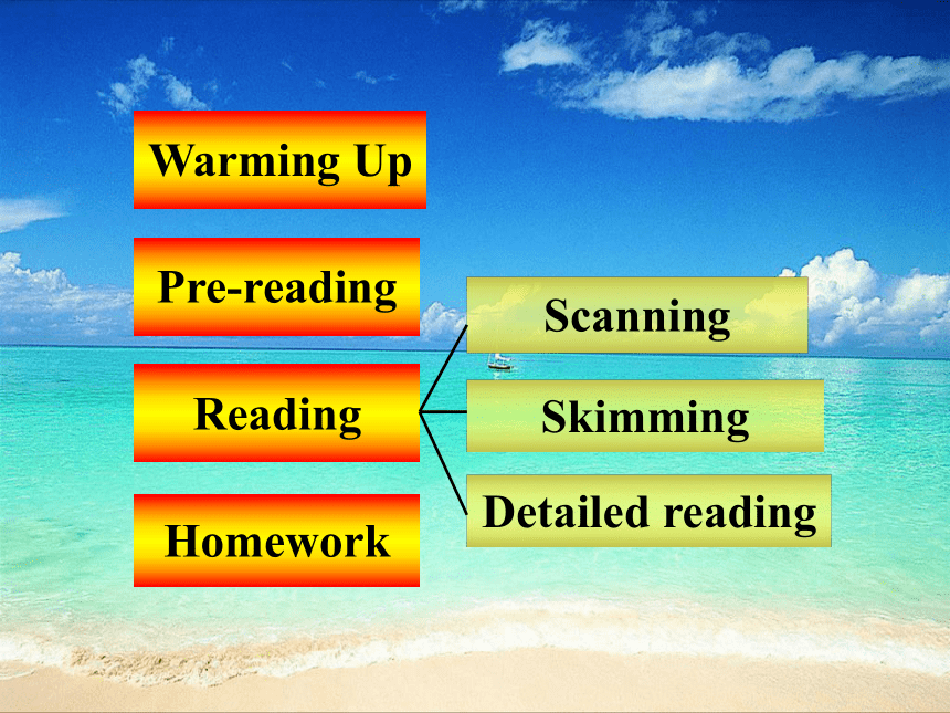
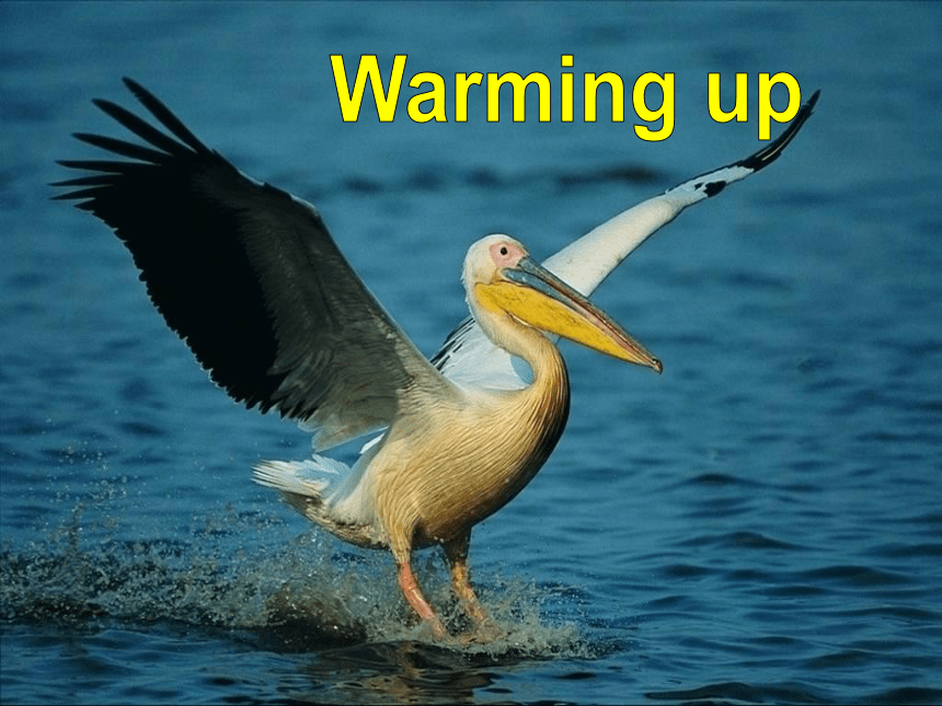
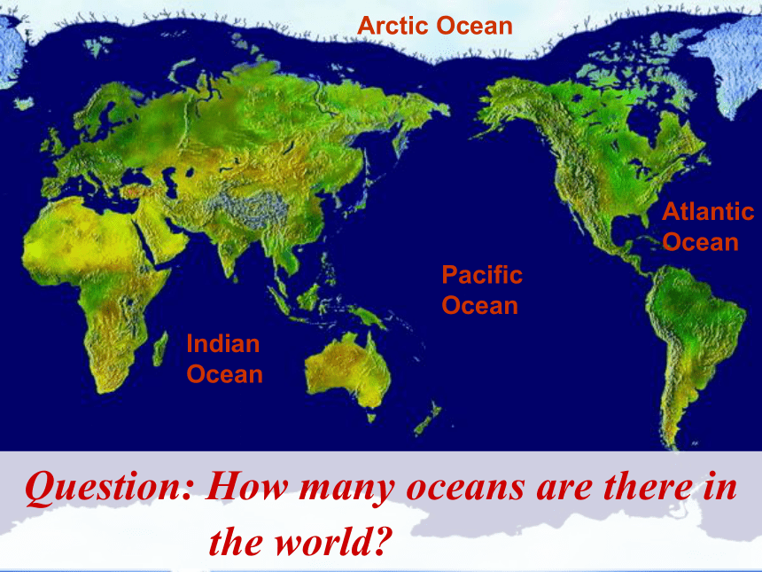
Unit 2Unit 2 Sailing the oceansReadingWarming UpPre-readingReadingScanningSkimmingDetailed readingHomeworkWarming upIndian OceanPacific OceanAtlantic OceanArctic OceanQuestion: How many oceans are there in
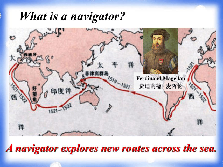
the world?Ferdinand Magellan 费迪南德 · 麦哲伦What is a navigator?A navigator explores new routes across the sea.Vasco da Gama 瓦斯科 · 达伽马Christopher Columbus
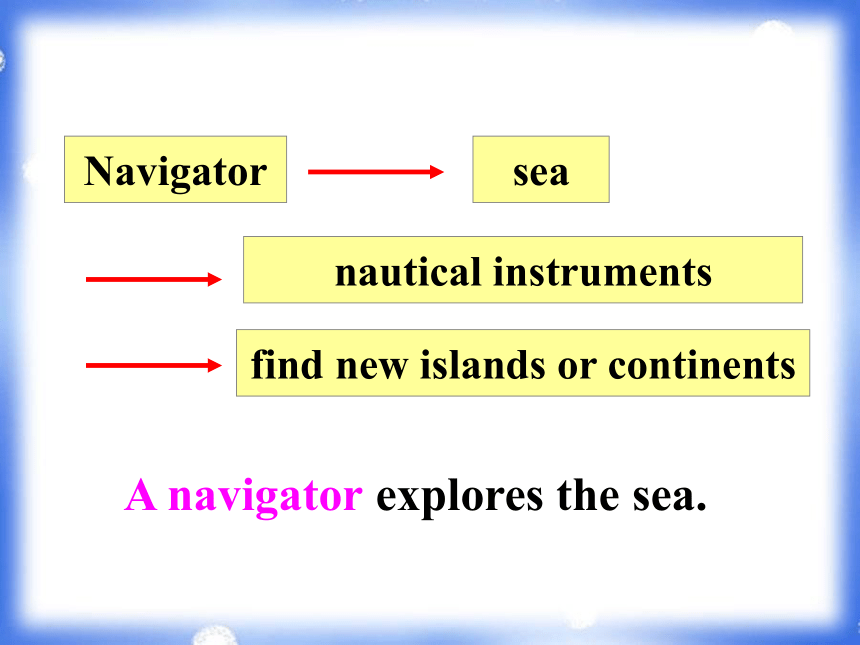
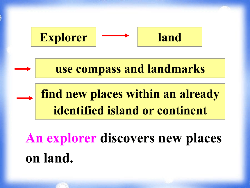
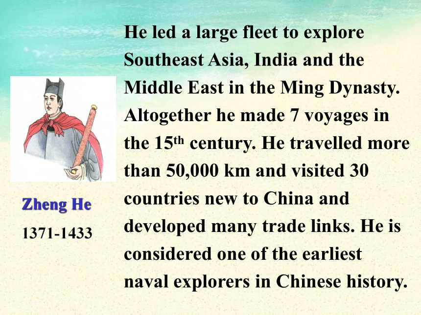
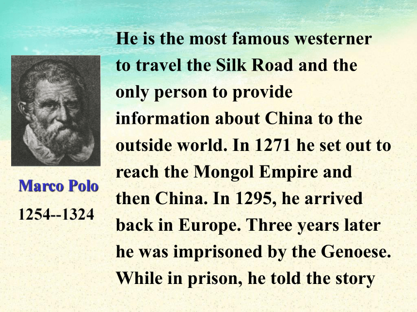
克里斯托弗 · 哥伦布What is the difference between a navigator and an explorer?Navigatorseanautical instrumentsfind new islands or continentsA navigator explores the sea.Explorerlanduse compass and landmarksfind new places within an already identified island or continent An explorer discovers new places on land. Zheng HeMarco PoloJames CookLook at these famous people. Are they navigators or explorers? What do you know about them?Zheng He
1371-1433He led a large fleet to explore
Southeast Asia, India and the
Middle East in the Ming Dynasty. Altogether he made 7 voyages in the 15th century. He travelled more than 50,000 km and visited 30 countries new to China and developed many trade links. He is considered one of the earliest
naval explorers in Chinese history.Marco Polo
1254--1324He is the most famous westerner
to travel the Silk Road and the only person to provide information about China to the outside world. In 1271 he set out to reach the Mongol Empire and then China. In 1295, he arrived back in Europe. Three years later he was imprisoned by the Genoese. While in prison, he told the storyof his travels to a fellow prisoner who wrote his adventures down. When his book was published it became a best-seller.The Map of Marco Polo’s voyageJames Cook1728-1779James Cook was the greatest Britain navigator. Cook joined in the Royal Navy in 1755. In 1768 he was promoted and sent to the Pacific where he surveyed Tahiti, New Zealand, and Australia. On his famous second expedition (1772-1775) he explored Antarctica. In 1776 he undertook his third and finalvoyage in which he explored the West Coast of North America and tried to locate a passage between the Atlantic and Pacific oceans.
On this voyage he discovered the Hawaiian Islands, and sailed up the coast of North America through the Bering Straits to the Arctic Ocean. On his return he was killed by Hawaiian islanders.
He is regarded as one of the world’s greatest explores and navigators.Pre-readingThe four basic instruments for navigation: compass, astrolabe, sextant and nautical chart.compassastrolabesextantnautical chartAnswer the questions.1. How do you think seamen found their way before modern accurate methods of navigation were invented?Kept close to the shore, used nature such as the sun, wind, birds, tide, etc, to help them, and used some of the instruments including a compass, astrolabe, etc.2. Which do you think was easier to work out: latitude or longitude?Latitude, because it was used to measure how far you had traveled from land on a straight line. It was discovered a long time before longitude.3. Can you identify these early navigational instruments seamen used and explain how they are used?1) compass (in ancient China)
2) astrolabe
3) sextant
4) sea / nautical / marine chart4. Which ones do you think are still used
today?Sea charts are still used today.Sailing the oceansRead about what navigation was like before modern instruments were used.Scanning How did seamen explore the oceans before latitude and longitude made it possible to plot a ship’s position?Page 1Using nature Keeping alongside the coastline
Using celestial bodies
Using wildlife
Using the weather
Using the seaUsing celestial bodiesto plot the positionsto work out the latitudea special cloud formation which indicates there is land close byNorth StarSunCloudsUsing wildlifeIf seaweed was fresh and smelled strongly, the ship was close to land.Seabirds could be used to show the way to land when it was nowhere to be seen.SeaweedBirdsUsing the weatherfogTo help identify the position of a stream or river when …To direct their sailingWindsUse the information to analyze the navigational skills and write the answers in your own words.To find the ship’s position at sea a sailor used _______________________.
A sailor knew that land was nearby if he saw ______________________________ _________________________________.
Sailors used ______________________ ______ to increase their speed.the North Star and the sunsea currents or tides andwindsUsing nature clouds, fresh seaweed, nesting birds returning home in the evening or fog What skills did sailors use to explore the seas and discover new lands?Page 2Using navigational instruments 1. Finding longitude 2. Finding latitudethe compass the bearing circle (方位圆) the astrolabe (星盘) the quadrant (象限仪, 四分仪) the sextant (六分仪)Read again and fill in the blanks.There were two methods to find longitude: 1. __________________________
2. __________________________
______________________measuring time and speedcompass and complicatedmathematical tablesUsing instruments Write down the working principles of the following instruments.
Bearing circle:
Astrolabe: to compare the height of the sun now with the position of the sun at midday. to compare the position of the ship in relation to some stars or the sun. Quadrant:a more precise form of the astrolabe, to measure how high stars are above the horizon, and compare that measurement with previous measurements (using the ship as one of the fixed points to find its position) Sextant:an updated version of the quadrant and so it was more accurate, to measure the angle between two fixed points outside the ship (using two mirrors to find the ship’s position). horizonSun heightA Bearing CircleBearing the sun --- height and azimuth (The marks were used to measure the shadow of the sun and its height and position in the sky.)(方位)Read the passage and answer the following questions. What is the use of a bearing circle, astrolabe, quadrant or sextant? ( ) What is the use of a compass? ( ) A. to set the course of the ship B. to measure the position of the ship C. to measure the speed of the ship
D. to tell the timeBAUsing instruments Skimming Skim the text and fill in the blanks.plotlatitudeWildlifewayidentifytides and currentscompasssextantDetailed reading1. Read the passage carefully and then answer the questions.1) Why are speed and time important in working out the longitude of a ship?
Speed and time are important in finding out the longitude of a ship because the earth moves fifteen degrees westwards every hour. If you know your direction, speed and time, you can work out the approximate longitude or change in your position in relation to the stars.2) Why is the position of the sun and
various stars useful for working out
latitude?
The position of the sun and stars are useful for working out latitude because they are fixed points in the sky and their movements in relation to the earth are already known. So they can be used to measure a ship’s position.2. Suppose you were a sea captain aiming to sail round Africa. Discuss in groups.
1) What skills would you seek in your sailors?
2) What problems would you anticipate for this journey?wait till the storm is over, and then find your new position and return to your original course3. Read the chart below and fill in your
plans of action to deal with them.use knots to find your speed and work out your approximate longitudeuse the compass and the astrolabe, quadrant or sextant to find out your position, return to your former course follow nesting birds to shore;
look for special cloud formations or fog over streams to find landuse a compassmeasure your position using the sun or stars; look for sea birds, cloud formations, fog or seaweed to show that land is nearby4. Imagine you are on a boat with twenty-nine other people. You have a small box for your personal things but it can only hole ten items. What would you need for a week’s journey across the North Sea to England?soapblanketcards, chessshirt, trousersknife, scissorssea-sick tablets, cold medicinenovels, essay collectionswaterproof bootsHomework1. Review this passage.
2. Preview Learning
about language.
高三 选修 9
Unit 2Unit 2 Sailing the oceansReadingWarming UpPre-readingReadingScanningSkimmingDetailed readingHomeworkWarming upIndian OceanPacific OceanAtlantic OceanArctic OceanQuestion: How many oceans are there in
the world?Ferdinand Magellan 费迪南德 · 麦哲伦What is a navigator?A navigator explores new routes across the sea.Vasco da Gama 瓦斯科 · 达伽马Christopher Columbus
克里斯托弗 · 哥伦布What is the difference between a navigator and an explorer?Navigatorseanautical instrumentsfind new islands or continentsA navigator explores the sea.Explorerlanduse compass and landmarksfind new places within an already identified island or continent An explorer discovers new places on land. Zheng HeMarco PoloJames CookLook at these famous people. Are they navigators or explorers? What do you know about them?Zheng He
1371-1433He led a large fleet to explore
Southeast Asia, India and the
Middle East in the Ming Dynasty. Altogether he made 7 voyages in the 15th century. He travelled more than 50,000 km and visited 30 countries new to China and developed many trade links. He is considered one of the earliest
naval explorers in Chinese history.Marco Polo
1254--1324He is the most famous westerner
to travel the Silk Road and the only person to provide information about China to the outside world. In 1271 he set out to reach the Mongol Empire and then China. In 1295, he arrived back in Europe. Three years later he was imprisoned by the Genoese. While in prison, he told the storyof his travels to a fellow prisoner who wrote his adventures down. When his book was published it became a best-seller.The Map of Marco Polo’s voyageJames Cook1728-1779James Cook was the greatest Britain navigator. Cook joined in the Royal Navy in 1755. In 1768 he was promoted and sent to the Pacific where he surveyed Tahiti, New Zealand, and Australia. On his famous second expedition (1772-1775) he explored Antarctica. In 1776 he undertook his third and finalvoyage in which he explored the West Coast of North America and tried to locate a passage between the Atlantic and Pacific oceans.
On this voyage he discovered the Hawaiian Islands, and sailed up the coast of North America through the Bering Straits to the Arctic Ocean. On his return he was killed by Hawaiian islanders.
He is regarded as one of the world’s greatest explores and navigators.Pre-readingThe four basic instruments for navigation: compass, astrolabe, sextant and nautical chart.compassastrolabesextantnautical chartAnswer the questions.1. How do you think seamen found their way before modern accurate methods of navigation were invented?Kept close to the shore, used nature such as the sun, wind, birds, tide, etc, to help them, and used some of the instruments including a compass, astrolabe, etc.2. Which do you think was easier to work out: latitude or longitude?Latitude, because it was used to measure how far you had traveled from land on a straight line. It was discovered a long time before longitude.3. Can you identify these early navigational instruments seamen used and explain how they are used?1) compass (in ancient China)
2) astrolabe
3) sextant
4) sea / nautical / marine chart4. Which ones do you think are still used
today?Sea charts are still used today.Sailing the oceansRead about what navigation was like before modern instruments were used.Scanning How did seamen explore the oceans before latitude and longitude made it possible to plot a ship’s position?Page 1Using nature Keeping alongside the coastline
Using celestial bodies
Using wildlife
Using the weather
Using the seaUsing celestial bodiesto plot the positionsto work out the latitudea special cloud formation which indicates there is land close byNorth StarSunCloudsUsing wildlifeIf seaweed was fresh and smelled strongly, the ship was close to land.Seabirds could be used to show the way to land when it was nowhere to be seen.SeaweedBirdsUsing the weatherfogTo help identify the position of a stream or river when …To direct their sailingWindsUse the information to analyze the navigational skills and write the answers in your own words.To find the ship’s position at sea a sailor used _______________________.
A sailor knew that land was nearby if he saw ______________________________ _________________________________.
Sailors used ______________________ ______ to increase their speed.the North Star and the sunsea currents or tides andwindsUsing nature clouds, fresh seaweed, nesting birds returning home in the evening or fog What skills did sailors use to explore the seas and discover new lands?Page 2Using navigational instruments 1. Finding longitude 2. Finding latitudethe compass the bearing circle (方位圆) the astrolabe (星盘) the quadrant (象限仪, 四分仪) the sextant (六分仪)Read again and fill in the blanks.There were two methods to find longitude: 1. __________________________
2. __________________________
______________________measuring time and speedcompass and complicatedmathematical tablesUsing instruments Write down the working principles of the following instruments.
Bearing circle:
Astrolabe: to compare the height of the sun now with the position of the sun at midday. to compare the position of the ship in relation to some stars or the sun. Quadrant:a more precise form of the astrolabe, to measure how high stars are above the horizon, and compare that measurement with previous measurements (using the ship as one of the fixed points to find its position) Sextant:an updated version of the quadrant and so it was more accurate, to measure the angle between two fixed points outside the ship (using two mirrors to find the ship’s position). horizonSun heightA Bearing CircleBearing the sun --- height and azimuth (The marks were used to measure the shadow of the sun and its height and position in the sky.)(方位)Read the passage and answer the following questions. What is the use of a bearing circle, astrolabe, quadrant or sextant? ( ) What is the use of a compass? ( ) A. to set the course of the ship B. to measure the position of the ship C. to measure the speed of the ship
D. to tell the timeBAUsing instruments Skimming Skim the text and fill in the blanks.plotlatitudeWildlifewayidentifytides and currentscompasssextantDetailed reading1. Read the passage carefully and then answer the questions.1) Why are speed and time important in working out the longitude of a ship?
Speed and time are important in finding out the longitude of a ship because the earth moves fifteen degrees westwards every hour. If you know your direction, speed and time, you can work out the approximate longitude or change in your position in relation to the stars.2) Why is the position of the sun and
various stars useful for working out
latitude?
The position of the sun and stars are useful for working out latitude because they are fixed points in the sky and their movements in relation to the earth are already known. So they can be used to measure a ship’s position.2. Suppose you were a sea captain aiming to sail round Africa. Discuss in groups.
1) What skills would you seek in your sailors?
2) What problems would you anticipate for this journey?wait till the storm is over, and then find your new position and return to your original course3. Read the chart below and fill in your
plans of action to deal with them.use knots to find your speed and work out your approximate longitudeuse the compass and the astrolabe, quadrant or sextant to find out your position, return to your former course follow nesting birds to shore;
look for special cloud formations or fog over streams to find landuse a compassmeasure your position using the sun or stars; look for sea birds, cloud formations, fog or seaweed to show that land is nearby4. Imagine you are on a boat with twenty-nine other people. You have a small box for your personal things but it can only hole ten items. What would you need for a week’s journey across the North Sea to England?soapblanketcards, chessshirt, trousersknife, scissorssea-sick tablets, cold medicinenovels, essay collectionswaterproof bootsHomework1. Review this passage.
2. Preview Learning
about language.